In 1999, getting to Koh Chang did not feel particularly complicated. It just felt like travelling to an island.
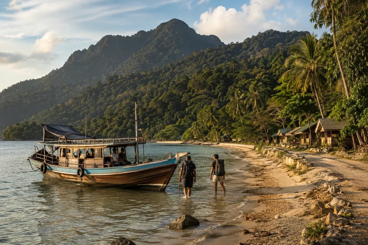
There was no polished arrival experience waiting at the other end. On my first visit, the final stretch was made by a much smaller boat than the vehicle ferries most visitors associate with Koh Chang today. When we reached the island, there was no grand terminal to walk into.
You got off the boat. Into the water. Then you made your way ashore.
The roads did not look much like the Koh Chang roads of today either. There was development, of course, but much of the island still felt connected by rougher, simpler roads rather than the established tourist infrastructure visitors now take for granted.
It felt remote. Not impossibly remote — not some lost island untouched by the modern world — but far enough away that arriving still felt like part of the adventure.
And 1999 turns out to have been a particularly interesting time to see it.
Research into Koh Chang's development places the late 1990s right around the point when tourism infrastructure began accelerating. A Chulalongkorn University study divides the island's modern tourism development into three broad phases: very limited tourism before 1985, a wave of bungalow and hotel building between 1986 and 1996, and a much stronger expansion of tourism facilities from 1997 onward.
So this was not the Koh Chang of fifty years earlier. But it was not yet the Koh Chang of today, either. It was an island somewhere in between.
And perhaps the best place to begin its story is with the elephant.
Why Is It Called Koh Chang?
The literal part is easy. Ko — usually written Koh in English — means island. Chang means elephant. So the literal meaning is simple: Elephant Island.
Exactly how the name originated is less certain. The most familiar explanation links it to the island's mountainous silhouette, which from the sea has long been compared to an elephant, while local folklore offers other stories. What is beyond doubt is that the name fits an island whose mountains dominate almost every view.
But the elephant in the name is more useful than simply giving tourists something memorable to put on a T-shirt. It introduces the feature that has probably shaped Koh Chang more than anything else: its geography.
Koh Chang is one of Thailand's largest islands, but comparisons with Phuket become misleading very quickly. Phuket has substantial flat, urbanised areas and its own international airport. Koh Chang is far more mountainous and heavily forested, and it remains dependent on ferries for access. Thailand's tourism authority describes the island as roughly 30 kilometres long and 14 kilometres wide, with a large share of its landscape still covered by rainforest.
That mountainous spine matters. There was never an enormous empty plain waiting for someone to draw a neat road grid across it. The usable coastal strips are narrow in many places, the interior rises steeply, and roads have to follow the landscape rather than ignore it.
That helped decide where people lived. Later, it helped decide where tourists stayed. And eventually, it helps explain why some parts of Koh Chang developed quickly while others have stayed comparatively quiet.
The elephant-shaped island, in other words, wrote the rules from the start.
Before Koh Chang Became a Resort Island
It is tempting to talk about Koh Chang as though nothing happened there until backpackers arrived carrying Lonely Planet books and questionable trousers. Obviously, that is not the case.
Before tourism became the island's dominant outside image, the communities that developed on Koh Chang were closely connected to fishing, agriculture, trade and the sea. The sheltered southeastern side of the island was particularly important. The Tourism Authority of Thailand describes Salak Phet Bay as having historically served as a sheltered harbour, where vessels could escape monsoon weather and take on food and fresh water.
Communities such as Salak Phet and Salak Khok still offer glimpses of a Koh Chang whose relationship with the water was not originally built around snorkelling trips and sunset cocktails. Fishing remains part of that heritage. At Salak Khok, for example, a community tourism initiative grew up around an old fishing village surrounded by mangroves, with local residents using tourism as an additional source of income rather than replacing every older activity with hotels.
That distinction matters. Koh Chang did not wake up one morning and become a tourist island. It changed gradually. Old livelihoods remained while new ones appeared beside them. Then tourism grew larger. Then the infrastructure began catching up.
When the Backpackers Found It
By the 1980s and early 1990s, Koh Chang was beginning to appear on the informal travel routes followed by independent travellers. This was not yet the world of booking apps, resort comparison sites and airport transfer packages. Visitors often arrived looking for simple accommodation and found basic bungalow operations close to the beaches.
The Chulalongkorn research is useful here because it lays that change out in a clear sequence. Before 1985, tourism development remained very limited. Between 1986 and 1996, the number of bungalows and hotels increased. After 1997 came a much broader expansion of tourism facilities.
That makes the 1990s a particularly interesting decade. Koh Chang was no longer unknown, but the machinery of mass tourism had not fully arrived. A traveller could reach the island and find beaches that already had accommodation, without the sense that the entire coastline had been organised around tourism.
And the roads were still part of the story. A later spatial study of Koh Chang's development identifies an early dirt route from around 1990, connecting the White Sand Beach area with Chai Chet and Kai Bae along the west coast.
That small detail explains a lot. Today, travellers think of White Sand Beach, Klong Prao, Kai Bae and Lonely Beach as stops along the same west-coast road. In the early stages of tourism development, simply connecting those places was itself part of the transformation.
The Koh Chang of 1999
This is where personal memory and the historical record line up in a satisfying way.
My memory of Koh Chang in 1999 is of arriving by a small boat, stepping into the water, and reaching an island where the road network still felt rough and incomplete. A surviving tourist map from that same year shows just how different the transport system was. Instead of today's familiar reliance on car ferries, visitors could use various smaller boat services from the mainland. Some went directly toward areas such as White Sand Beach, Chai Chet, Bang Bao and Salak Phet. The map also shows how the road situation limited travel further south along the west coast.
That does not prove every visitor in 1999 arrived the way I did. They clearly did not. But it confirms something more important: there were far more small-boat arrival patterns than the standardised ferry experience most visitors know today, and the southern road network was still very much a work in progress.
That is what makes an old travel memory worth something — when it can be checked against the record. The memory is personal. The changing island is not.
The Ferries Changed More Than the Journey
It is easy to think of better ferry access purely as something that helped tourists. It did. But ferries change islands in much bigger ways than that.
A passenger carries a backpack. A vehicle ferry carries cars, trucks, food, construction materials, furniture, machinery, fuel and almost everything else needed to build a modern destination.
Research into Koh Chang's physical development identifies 1996 as an important moment, when construction began on commercial port infrastructure in the north as part of wider efforts to develop tourism in eastern Thailand. Once regular vehicle access became easier, development gained momentum. A resort no longer had to operate in quite the same logistical world as an isolated bungalow operation. Building materials could arrive more easily. Supplies became simpler to move. Visitors could bring their own vehicles. Tour companies could move people around more efficiently.
Eventually, the ferry itself stopped feeling like an adventure and became part of the transport system. That sounds less romantic. It is also extremely useful if you actually live on the island.
Modern infrastructure rarely arrives because somebody wants to ruin a good travel story. Usually it arrives because communities want reliable transport, electricity, supplies, schools, healthcare, jobs and easier connections to the rest of the country. On Koh Chang, tourism and local development grew up together.
The Road South
If the ferries opened the door, the road network decided where much of the new activity went.
The western side of Koh Chang held the beaches that became most famous with visitors, and improved road access gradually connected them. White Sand Beach became the most obvious gateway into the island's resort economy. Further south came Klong Prao and Kai Bae. Then Lonely Beach. And eventually Bang Bao.
There is a big difference between seeing those places as individual pockets reached only with effort, and seeing them as stops along one continuous tourism corridor. Research examining land-use change on Koh Chang from 1990 onward found that the west coast saw some of the strongest transformation, with agricultural and less-developed land increasingly replaced by accommodation, commercial development and tourism infrastructure.
Again, this should not be turned into a morality play. Development created environmental pressures. It also created livelihoods, easier movement and real economic opportunity. The interesting part of the story is how quickly the balance shifted.
A dirt track becomes a paved road. A bungalow becomes a resort. A beach name becomes an internationally searchable destination. Then, one day, somebody complains that the Wi-Fi is slow. Progress has a sense of humour.
White Sand Beach: The Natural First Stop
White Sand Beach — Hat Sai Khao — was almost destined to become one of Koh Chang's major visitor centres. It sits relatively close to the northern ferry approaches, has a long, attractive beach, and became one of the easiest places for new arrivals to understand. The Tourism Authority of Thailand still lists White Sand Beach among the island's principal visitor areas.
As access improved, the area accumulated exactly the things successful tourism centres tend to accumulate: more accommodation, more restaurants, more shops, more transport — and then more accommodation, because all the other pieces were already there. Development reinforces itself.
That does not mean White Sand stopped being Koh Chang. It became one particular version of Koh Chang. And that distinction matters, because the island never developed evenly.
Lonely Beach: When Backpacker Koh Chang Grew Up
Even the name feels like a leftover from another era. Lonely Beach. It sounds like somewhere you reached after several hours on a questionable boat and then disappeared for six weeks.
As access improved, Lonely Beach became one of Koh Chang's best-known backpacker areas. Simple accommodation, a social travel culture and relatively low prices gave it an identity distinct from the more established resort environment further north.
Then, inevitably, backpackers told other backpackers. Guidebooks told more people. The internet told everyone. And the word "lonely" became increasingly theoretical.
Still, its evolution captures the wider Koh Chang story nicely. Tourism rarely arrives as a single industry all at once. First come adventurous independent travellers. Then family-run accommodation. Then restaurants and bars. Then better roads. Then larger operators. Then travellers who would never have considered visiting during the first stage. Each group makes the destination a little easier for the next.
Bang Bao: A Village at the End of the Road
Bang Bao offers an even clearer example of how tourism and older island life can overlap. The settlement grew up around the water, with buildings extending outward on stilts and fishing forming an important part of local life.
As Koh Chang tourism expanded, Bang Bao also became a departure point for boat trips, diving and excursions to smaller islands. Restaurants and visitor businesses appeared alongside the older village structure. Today it can feel simultaneously like a fishing community and a tourism attraction.
That may sound contradictory. It is actually normal. Places do not stop being real communities simply because tourists find them interesting, and communities do not necessarily want to stay frozen in whatever year outsiders first thought they looked "authentic." The story is more interesting when Koh Chang's residents are allowed the same thing everyone else wants: the ability to shape their own lives.
The Other Koh Chang
Most discussions of Koh Chang naturally drift toward the west coast, where many of the famous beaches and resorts are found. But the east side tells a different story. There are mangrove areas, smaller settlements, fishing communities and agricultural landscapes where development followed a different rhythm.
Salak Khok is one example. Salak Phet is another. The Tourism Authority of Thailand continues to promote community-based and nature-focused activities in these areas, including mangrove environments and fishing-community experiences.
This helps explain something visitors often only discover after spending more time on the island: there isn't really one Koh Chang. There is the resort corridor, the backpacker history, the fishing communities, the forested mountains, the east coast, the ferry gateways, the beaches, the villages. They all occupy the same island without developing at exactly the same speed.
The National Park in the Middle of the Story
There is another reason Koh Chang never became one continuous strip of development: a large part of its identity is tied up in Mu Ko Chang National Park.
The park was established in 1982 as Thailand's 45th national park and includes Koh Chang along with the surrounding islands and marine environment. That matters for both conservation and development. Koh Chang's mountainous interior remains heavily forested, and the protected landscape has helped preserve the dramatic green backdrop that still dominates views across the island.
It also means the island's development story is not simply "tourists arrived, hotels covered everything." Physical constraints and conservation status have always complicated that process. The forested centre remains visually dominant. Waterfalls remain major attractions. The coastline may change, but the mountains behind it keep reminding you exactly what island you are on.
Why Koh Chang Never Became Phuket
This comparison needs some care. Phuket is not the villain in Koh Chang's story. Phuket developed according to its own geography, history, infrastructure and economy, and became one of Asia's major international resort destinations in its own right.
Koh Chang simply followed a different route. There are obvious structural differences. Phuket is connected to the mainland by bridges and has an international airport on the island. Koh Chang still requires a ferry — visitors generally travel through the mainland, with Trat Airport nearby but still requiring onward transport and a ferry crossing.
Koh Chang is also highly mountainous. Its tourism infrastructure tends to stretch along the usable coastal strips rather than spread across a broad, urbanised island. The ferry remains a natural bottleneck, and even as tourism grew enormously, the physical geography kept pushing development into particular corridors.
That is not better or worse. It is simply why Koh Chang still feels like Koh Chang. You cannot entirely remove the island from the journey. There is always that final crossing.
When an Island Becomes Easy
Perhaps the biggest difference between Koh Chang in 1999 and Koh Chang today is not any individual hotel, road or restaurant. It is that the island became easier.
Easier to find. Easier to book. Easier to reach. Easier to drive around. Easier to understand before you even arrive. Modern travellers can inspect accommodation photographs, read reviews, compare beaches, check ferry schedules and know roughly what their room will look like before leaving home. In 1999, a much larger part of the experience happened after you arrived.
That does not automatically make one style of travel better. Anyone who has spent hours carrying luggage while trying to locate accommodation in tropical heat may have some strong opinions about the romance of spontaneous travel. Modern convenience has considerable charm when it is 34°C outside.
But something does change psychologically when uncertainty disappears. An island can stop feeling distant long before it physically moves any closer.
What Remains
The remarkable thing is how much of Koh Chang still refuses to behave like a fully urbanised resort island.
The mountains are still there. The jungle is still there. The road still climbs and twists along the coast. The ferry still separates the island from the mainland. The eastern side can still feel remarkably different from the busier west. Fishing communities still exist. Mangroves still exist. And large parts of the island still look overwhelmingly green when seen from the sea.
This is probably the wrong place for the familiar line about a destination being "spoiled." Koh Chang changed because people discovered it. Thai visitors discovered it. Foreign visitors discovered it. Businesses invested. Families built livelihoods. Roads improved. Transport improved. People moved there. Children grew up. Communities changed. That is what places do.
The interesting question is not whether Koh Chang stayed frozen in the year somebody first fell in love with it. It is whether the character created by its geography, history and communities survived the transformation.
Much of it did.
Back to 1999
Looking back now, the clearest memory is not a hotel or a restaurant. It is the arrival.
A smaller boat. Shallow water. Stepping down rather than walking into a ferry terminal. Then an island connected by roads that felt much rougher and less complete than the ones visitors know today.
At the time, none of it felt historically significant. It was simply how you got to Koh Chang.
That is the funny thing about watching a place change. Nobody puts up a sign saying: You are currently experiencing the end of an era. Please take notes. You only understand the transition later.
Research now places that trip almost perfectly at the dividing line. Tourism had already arrived. Bungalows and hotels already existed. The first stages of the western road network had been developing for years. Commercial ferry infrastructure was beginning to make access easier. And from the late 1990s onward, tourism facilities and construction expanded much more rapidly.
I did not visit an untouched island. I visited an island halfway through becoming something new. And perhaps that is what makes the memory interesting.
The Koh Chang of 1999 has not disappeared completely. You can still see it in the mountains. In the fishing villages. In the mangroves. In the stretches of road where the forest suddenly closes in around you. And every time the ferry leaves Trat behind and the dark green shape of the island begins rising from the water, the name still makes perfect sense.
Elephant Island. Older. Busier. Easier to reach. But still unmistakably Koh Chang.