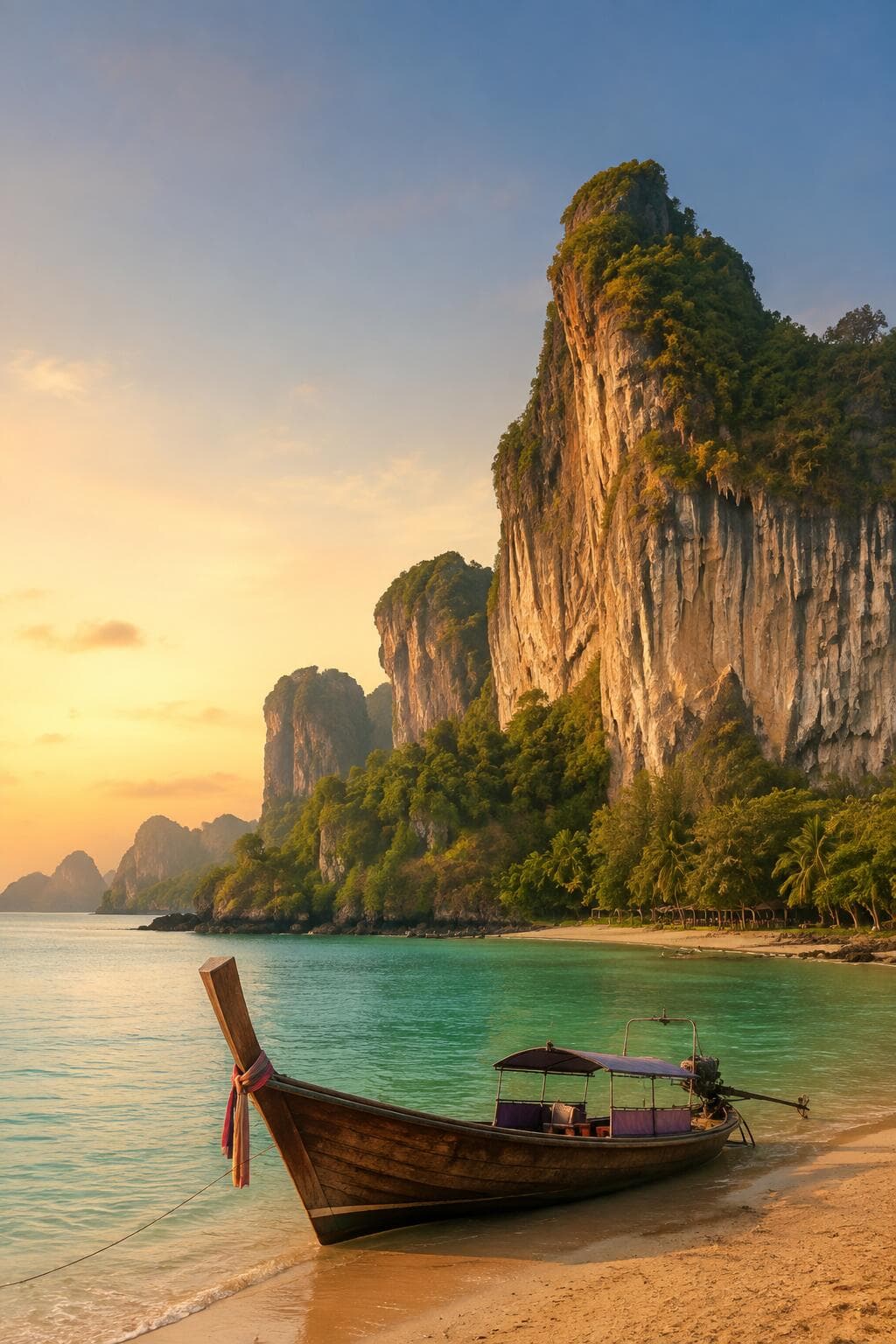
A long-tail boat rounds a headland, engine sputtering, and suddenly there they are: vertical walls of limestone rising straight out of turquoise water, streaked grey and green, topped with scrubby forest that somehow clings to near-vertical rock. It looks designed. It looks like someone built a film set and forgot to take it down.
Nobody built it. Krabi looks like Krabi because of geology, not design — and that single fact turns out to explain almost everything else about how this province became one of Thailand's most recognisable destinations.
This is not a story about a famous resort or a single event that put Krabi on the map. It is a story about a landscape that kept deciding what could happen here — where people could settle, where roads could go, which beaches stayed hard to reach, and, eventually, what kind of visitors the place would attract once the rest of the world noticed.
Why Krabi Looks Like Krabi
Krabi's most recognisable feature is its limestone karst landscape — steep towers, cliffs, caves and islands scattered along the coast and rising out of the sea offshore. The Tourism Authority of Thailand highlights these limestone cliffs as one of the province's major attractions in their own right, and specifically notes that they draw rock climbers from around the world.
This makes Krabi somewhat unusual among tourist destinations. Many places are defined by a city, a monument or a single historical narrative. Krabi is defined by the shape of the land itself. Limestone karst forms over very long periods, as water gradually dissolves and erodes the rock, producing the dramatic towers, sheer cliff faces and hidden caves that now define the province's coastline and islands. The precise geological history of any individual formation is a matter for specialists rather than for a visitor's introduction to the region — what matters here is simpler: this landscape existed, largely as it looks today, long before anyone thought to build a resort near it.
It is worth sitting with that distinction for a moment, because it changes how the rest of this story should be read. A destination built around a historic town, or a single monument, tends to have a clear moment of origin — a founding, a construction, an event that can be pointed to as the beginning of its fame. Krabi has no equivalent single moment. Its fame is distributed across an entire landscape, shaped over an immense span of geological time, long before the concept of tourism existed anywhere in the world. Everything that follows in this story is really about how people gradually found ways to reach, use and appreciate a landscape that was never designed with any of them in mind.
Krabi Town and Khao Khanap Nam — The Limestone Identity Before the Beach
The limestone story actually begins before most visitors ever reach the coast. Krabi Town, the province's administrative and commercial centre, sits on the Krabi River rather than on any of the resort beaches most travellers come to see.
At the river's entrance stand Khao Khanap Nam, two limestone hills that the Tourism Authority of Thailand officially describes as a symbol of Krabi. Their presence there, framing the approach to the provincial capital, is a useful reminder that Krabi's geological identity is not confined to its beaches. It announces itself at the river mouth long before a visitor reaches Ao Nang or Railay.
Krabi Town and the coastal resort areas serve genuinely different functions within the province, and neither should be read as more essential or more authentic than the other. Krabi Town carries the administrative and commercial life of the province. The coast carries its tourism economy. Both sit within the same limestone landscape.
Coastal Livelihoods Before Large-Scale Tourism
Long before large-scale tourism arrived, the Krabi coast supported fishing communities, agriculture and maritime movement, much as coastal provinces across southern Thailand did. Ko Klang, near Krabi Town, is still presented today by the Tourism Authority of Thailand as a fishing-village community destination — a living link to the kind of coastal livelihood that predates the resort economy and continues alongside it.
Areas that would later become tourism hubs, including Ao Nang itself, also contained agricultural land before large-scale development began. Land-use research on the area shows former agricultural and natural land being gradually converted as the tourism economy grew over subsequent decades. It would be a mistake to imagine a single, frozen version of "old Krabi" before all of this began — the province always contained a mix of settlements, livelihoods and levels of connection to the wider world, just as it does today.
That mix matters because it means Krabi's transition into a tourism destination did not require replacing one way of life with another across the whole province at once. Fishing communities like Ko Klang continued alongside the growth of Ao Nang. Agricultural land near the coast gave way gradually to accommodation and visitor services in some areas, while remaining agricultural land elsewhere. Krabi's story is less a single hinge point between "before" and "after" than a patchwork of different places changing, or not changing, at different speeds.
Ao Nang Becomes the Practical Gateway
Of all the places along the Krabi coast, Ao Nang is the one that grew most directly out of the province's geography.
The Tourism Authority of Thailand describes Ao Nang as the major launching point for boat trips to nearby islands and to the more isolated beaches of the Phra Nang Cape and Railay area. Modern Ao Nang developed into the principal mainland tourism strip along this coast, accumulating accommodation, restaurants, travel businesses and the boat infrastructure needed to reach places the road network simply could not.
Recent land-use research describes Ao Nang as having developed for Thai and international tourism since the early 1980s, and documents substantial urban expansion in the decades that followed. Read together, these facts sketch a clean and telling arc: a coastal settlement and agricultural landscape gradually added visitor services, became the boat gateway into the surrounding limestone geography, and grew, over time, into the larger tourism town it is today.
Railay: Mainland Landscape, Island-Like Access
If Ao Nang shows how the coast responded to geography, Railay shows how thoroughly that geography could shape a place on its own terms.
Railay sits on the Thai mainland — it is not an island. And yet the limestone cliffs that surround it cut it off so completely from the ordinary road network that access is, in practice, primarily by boat, usually from Ao Nang or Ao Nam Mao. It is one of the more genuinely surprising details in Krabi's story: a place that feels, in every practical sense, like an island, despite being firmly attached to the mainland the whole time.
The Tourism Authority of Thailand describes the beaches around Phra Nang Cape as isolated, reached from Ao Nang specifically by boat. That isolation did two things at once, and this dual role is worth keeping in mind throughout Krabi's story. The cliffs limited conventional road access and development in a way that would, in most places, simply hold a location back. In Railay's case, those same cliffs also created the dramatic scenery that would eventually make the place internationally famous. Obstacle and attraction, in this landscape, turn out to be the same rock formation.
Backpackers and the Early Beach-Tourism Era
Long before Railay became known internationally for rock climbing, it had already developed a reputation among a different kind of traveller. The Tourism Authority of Thailand's own material refers to Railay as a former hippie enclave — official confirmation of an earlier backpacker identity that predates the area's later, more structured tourism development.
Railay's boat-only access, its beaches and its cliffs made it a natural draw for independent travellers looking for somewhere that felt genuinely apart from the mainland resort circuit. Small-scale accommodation and simple beach-oriented tourism developed here well before the higher-end resorts that operate on Railay's beaches today. There is no need for a precise founding date or a single origin story to make the point clearly: the same physical isolation that made Railay difficult to reach in any conventional sense is precisely what made it desirable to travellers actively seeking somewhere off the beaten path.
Early 1980s: A More Organised Tourism Phase
Tourism in the Krabi area did not begin at any single identifiable moment, and it would be misleading to suggest it did. But the early 1980s stand out as a period when the region's visitor economy took on a more organised, structured shape.
Land-use research on Ao Nang specifically identifies the area as having developed for tourism since 1983. In the same year, Hat Noppharat Thara–Mu Ko Phi Phi National Park was established, creating an important protected framework around beaches, islands and marine landscapes closely associated with Krabi's tourism image. Travellers had already been visiting the region before this period, but the early 1980s mark the point at which Krabi's tourism economy began to acquire the more deliberate, planned character that would carry it into the following decades.
When People Began Climbing the Postcard
If any single development turned Krabi's scenery from a backdrop into an activity in its own right, it was rock climbing.
Railay and the Phra Nang Peninsula became internationally known as a rock-climbing destination on the same limestone cliffs that had once simply framed the beach. Official Thai tourism promotion explicitly markets Railay and the wider Krabi area as an international climbing destination, and an international climbing event connected to Thai tourism promotion described Krabi's limestone monoliths and coastal cliffs as having drawn climbers for years by the time the event took place. Specialist climbing sources describe hundreds of bolted routes spread across Railay, Tonsai and the surrounding walls, evidence of just how developed this particular niche of Krabi's tourism economy eventually became. Precise dates for exactly when the first climbers arrived are hard to pin down with confidence, resting mostly on specialist or anecdotal accounts rather than documented history — but by the 1990s and into the 2000s, Railay had clearly established itself internationally as a major climbing destination in its own right.
Why Climbing Matters Beyond Sport
It is worth pausing on why this particular development mattered so much to Krabi's identity, beyond simply adding one more activity to a list of things visitors could do.
Climbing changed the relationship between travellers and Krabi's scenery. The cliffs stopped being only a backdrop for beach photographs and became, quite literally, the activity itself — something to be touched, climbed and studied at close range rather than admired from a boat or a beach towel. This diversified Krabi well beyond passive beach tourism and gave Railay a genuinely distinctive international subculture, with climbing schools, professional guiding, route maintenance and dedicated climbing events all growing up around the same limestone walls that had once simply limited where roads could go.
The underlying point is a striking one: in Krabi, geology became both the scenery and the economic activity at the centre of it.
It is a rare kind of destination where the primary natural feature functions simultaneously as the view, the challenge and the workplace. A climbing guide in Railay makes a living from the same cliff face that a family photographs from a passing boat, and both are responding to the same rock, shaped the same way, for entirely different reasons.
Islands, Boats and the Wider Limestone Seascape
Krabi's tourism identity extends well beyond the mainland coast, out into a wider seascape of islands and marine landscapes that share the same limestone character. The Tourism Authority of Thailand highlights island trips from Ao Nang to destinations such as Ko Poda and the surrounding archipelago, alongside the broader national-park landscape that connects mainland beaches to their offshore counterparts.
Koh Phi Phi, administratively part of Krabi Province, belongs to this same wider seascape, though its story is a large and distinctive one in its own right, told separately elsewhere. For Krabi's own story, the islands matter chiefly as part of a broader visual identity — limestone rising directly out of the sea — that extends the same geological signature found onshore out across the water surrounding the province.
Ao Nang Expands as Visitor Infrastructure Grows
As Krabi's reputation grew through the climbing scene, island trips and beach tourism alike, Ao Nang changed dramatically to keep pace with rising demand.
Academic land-use research using satellite imagery, comparing the Ao Nang area from 1973 through to 2025, documents substantial expansion of built-up and commercial land across that period. The same research traces tourism development back to the early 1980s and identifies growth extending along the coast to include Ao Nang, Noppharat Thara, Railay, Khlong Muang and Tubkaek. This kind of urban growth is best read as evidence of the destination's increasing role and reach, not as a story of decline. There is a clean way to summarise the direction of cause and effect here: the coastline did not become famous because Ao Nang happened to already be a substantial town. Ao Nang became a substantial tourism town because the coastline it served had already become famous.
Why Krabi Never Became Just One Resort Town
Unlike destinations built around one continuous stretch of resort development, Krabi's physical geography naturally distributes tourism across several distinct nodes rather than concentrating it in a single strip.
Ao Nang functions as the main mainland hub. Railay sits physically separated by its cliffs, reachable only by boat. Krabi Town sits inland, up-river from the resort beaches, carrying on its own administrative and commercial life. Khlong Muang and Tubkaek, further north along the coast, developed their own quieter resort identities. And the offshore islands create additional visitor circuits layered on top of all of this.
This fragmented geography is very much part of Krabi's character rather than an accident of underdevelopment. It helps explain why a visit to Krabi so often feels like moving through a collection of related but distinct landscapes, each shaped by its own particular relationship with the same underlying limestone geology, rather than experiencing one uniform resort city stretched along a single beach.
A visitor moving between these nodes experiences Krabi almost as a series of related short trips rather than one continuous stay in one place: a boat out from Ao Nang, a short crossing to Railay, a longer excursion out to the islands, perhaps a stop in Krabi Town itself. Each stage of that movement is shaped by the same geological logic — where the cliffs allow easy passage, where they force a detour by water, and where they simply stop the road network altogether.
The Postcard Was Made by Geology
Krabi's global image is a strongly visual one: vertical limestone towers rising above turquoise water, long-tail boats threading between them, caves cut into cliff faces, beaches tucked beneath forested karst. It is worth being precise about what tourism actually did here, because it is easy to overstate. Tourism did not invent any of these features. What it did was find ways to package, access and experience a landscape that had already existed, largely unchanged, for a very long time before the first visitor boat ever crossed this stretch of coast.
Boat tours, climbing routes, kayaking trips, beach stays and lookout viewpoints all draw on exactly the same underlying geological landscape, packaged in different ways for different kinds of traveller. The postcard image so many people associate with Krabi was never really created by the tourism industry. It was simply discovered, and then made accessible.
The Landscape Is the Reason
Krabi did not become Krabi because somebody built a famous resort, or because a single event put the province on the map. Its identity grew, layer by layer, from a landscape that kept determining what could happen there.
The cliffs made some places genuinely hard to reach. That isolation is a large part of what made Railay so distinctive in the first place. Those same cliffs went on to attract climbers from around the world, turning an obstacle into one of the province's most recognisable modern activities. The islands offshore created their own boat routes and day-trip circuits, extending the same limestone identity out across the water. And Ao Nang grew into a substantial tourism town precisely because it was the practical gateway into all of this geography, not the other way around.
In Krabi, the landscape did not merely survive the arrival of tourism. It is the reason the tourism story exists here at all — and it is written into almost everything a visitor now comes to see, from the twin hills at the mouth of the Krabi River to the boat-only beaches of Railay to the cliffs above them, still being climbed today.
The clearest image of all of this might be the simplest one: a long-tail boat gliding beneath vertical limestone walls, a thoroughly modern tourism economy moving quietly through a landscape millions of years older than anything ever built around it.